Functional temporarily unavailable
Bila Skelia
Travel guide online Bila Skelia
General information about Bila Skelia
Village Bila Skelia is located on the territory of Autonomous Republic of Crimea and is administratively part of Bilohirsk district AR Crimea. According to the Codifier of Administrative Territorial Units and Territories of Territorial Communities of Ukraine, the settlement Bila Skelia has the code UA01040090020073644.
The district center of the Bilohirsk district is a city Bilohirsk. The distance from the district center to the settlement Bila Skelia is 4 kilometers in a straight line (the length of the road route may be longer).
The former T ...
Village Bila Skelia is located on the territory of Autonomous Republic of Crimea and is administratively part of Bilohirsk district AR Crimea. According to the Codifier of Administrative Territorial Units and Territories of Territorial Communities of Ukraine, the settlement Bila Skelia has the code UA01040090020073644.
The district center of the Bilohirsk district is a city Bilohirsk. The distance from the district center to the settlement Bila Skelia is 4 kilometers in a straight line (the length of the road route may be longer).
The former Tatar village of Ak-Kaya received the name Bila Skelia in 1948 after the forced deportation of Crimean Tatars by the Soviet occupiers from Crimea to Central Asia.
A detailed description of Bila Skelia, including geographical location, date of foundation, history of the settlement of Bila Skelia with main historical events and persons, main sights and interesting places of Bila Skelia, not yet available.
Cело Біла Скеля розташоване на території Автономної Республіки Крим та адміністративно входить до складу Білогірського району АР Крим. Згідно з Кодифікатором адміністративно-територіальних одиниць та територій територіальних громад України, населений пункт Біла Скеля має код UA01040090020073644.
Районним центром Білогірського району є місто Білогірськ. Відстань від райцентру до населеного пункта Біла Скеля становить 4 кілометри по прямій (довжина маршруту автомобільними дорогами може бути більшою).
Назву Біла Скеля колишнє татарське село Ак-Ка ...
Cело Біла Скеля розташоване на території Автономної Республіки Крим та адміністративно входить до складу Білогірського району АР Крим. Згідно з Кодифікатором адміністративно-територіальних одиниць та територій територіальних громад України, населений пункт Біла Скеля має код UA01040090020073644.
Районним центром Білогірського району є місто Білогірськ. Відстань від райцентру до населеного пункта Біла Скеля становить 4 кілометри по прямій (довжина маршруту автомобільними дорогами може бути більшою).
Назву Біла Скеля колишнє татарське село Ак-Кая отримало в 1948 році після примусової депортації кримських татар радянськими окупантами із Криму до Середньої Азії.
Детальний опис Білої Скелі, що включає географічне розташування, дату заснування, історію населеного пункта Біла Скеля з основними історичними подіями та персонами, основні пам'ятки та цікаві місця Білої Скелі, поки що відсутній.
Сплануй своє перебування у Bila Skelia
What to see and where to go in Bila Skelia
Tourist attractions and museums of Bila Skelia

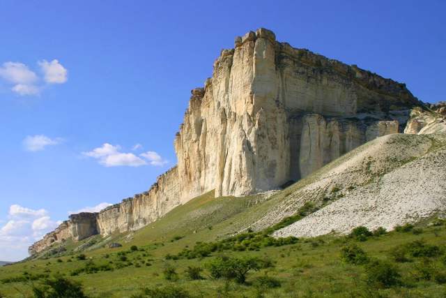
White Rock (Ak-Kaya)
Natural object
White Rock, which gave the current name Bilohirsk rises to the northeast of the city more than 150 meters. The Tatar name is Ak-Kaya.
The upper part of the southwestern slope is a grand cliff, exposing white limestone. Fossilized remains of various fossils of organisms from the Cretaceous period are often found in them. As a result of weathering, depressions, hills and ridges, canopies and caves appeared.
At the foot of the White Rock of Ak-Kaya, about twenty campsites and settlements of primitive man, as well as many Scythian monuments, were investigated.
A large panorama of the Crimean foothills planted with gardens opens from the top.
The one-of-a-kind landscape of the surrounding area on the border between the mountains and the steppe constantly attracts artists and cinematographers. Films popular in the 70s were shot here: "The Headless Horseman", "Mustang the Wanderer", "Cipollino" and others.
Reviews Bila Skelia
Geographical information about Bila Skelia
| {{itemKey}} | {{itemValue}} |
|---|---|
| Region |
Autonomous Republic of Crimea |


