Functional temporarily unavailable
General information about Lukyanivka
The village of Lukyanivka is located next to highway N-07 Kyiv - Sumy.
Known since the 18th century, marked on Guillaume de Beauplan's map.
The wooden Ascension Church (1758) was destroyed by the Russian invaders in 2022 during the full-scale Russian invasion of Ukraine during the retreat from the Kyiv region.
Село Лук'янівка розташоване поруч з трасою Н-07 Київ - Суми.
Відоме з XVIII сторіччя, позначене на карті Гійома де Боплана.
Дерев'яна Вознесенська церква (1758 рік) була знищена російськими окупантами у 2022 році в ході повномасштабного російського вторгнення в Україну при відступі з Київщини.
Сплануй своє перебування у Lukyanivka
What to see and where to go in Lukyanivka
Tourist attractions and museums of Lukyanivka
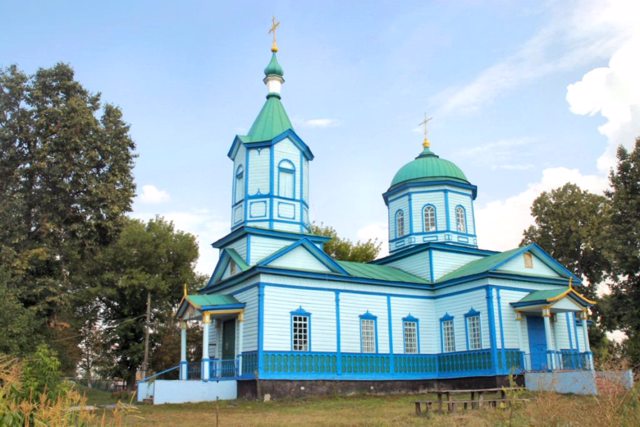
Ascension of Lord Church
Temple , Architecture
The Church of the Ascension of the Lord in Lukyanivka is a wooden church with one spherical dome and a bell tower above the vestibule.
Founded in 1758, rebuilt in its present form in 1879. According to church documents, the first rector of the church was priest Hryhoriy Favorskyi.
From 1930 to 1941, the Ascension Church was closed by the Soviet authorities. During the German occupation, Archpriest Ihnatiy Tune, who died in 1946 and was buried near the church, served in the Lukyanivka church. Since then, the Church of the Ascension remained active.
Russian-Ukrainian war
On March 25, 2022, at 4 o'clock in the morning, after the liberation of the village by the Armed Forces of Ukraine from the Russian invaders, the latter completely destroyed the church - a Russian tank fired four shots at the Church of the Ascension.
The dome and icons of the Ascension Church became exhibits of the National Museum of the History of Ukraine in the Second World War.
Lukyanivka on photo and video
Reviews Lukyanivka
Geographical information about Lukyanivka
| {{itemKey}} | {{itemValue}} |
|---|---|
| Region |
Kyiv |
