Functional temporarily unavailable


General information about Marynyn
The village of Marynyn on the banks of the Sluch River is located 10 kilometers east of Sosnove, 30 kilometers north of Korets.
It was mentioned for the first time in documents in 1488, although the Old Rus settlement existed as early as the 11th-13th centuries (the rampart has been preserved).
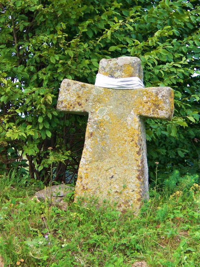
Later, a castle was built on the top of Prince's Mountain, which was first mentioned in 1577 as the property of Prince Bohush Koretskyi (not preserved). Around the same time, the prince founded the Marynyn Monastery (a stone cross has been preserved). A wooden Transfiguration Church was built on the site of the monastery in 1801, next to which a bell tower was erected in 1882.
The village of Marynyn is f ...
The village of Marynyn on the banks of the Sluch River is located 10 kilometers east of Sosnove, 30 kilometers north of Korets.
It was mentioned for the first time in documents in 1488, although the Old Rus settlement existed as early as the 11th-13th centuries (the rampart has been preserved).
Later, a castle was built on the top of Prince's Mountain, which was first mentioned in 1577 as the property of Prince Bohush Koretskyi (not preserved). Around the same time, the prince founded the Marynyn Monastery (a stone cross has been preserved). A wooden Transfiguration Church was built on the site of the monastery in 1801, next to which a bell tower was erected in 1882.
The village of Marynyn is famous for its stunning views of the rocky valley of the Sluch River from the height of the coastal hills - it is part of the Nadsluchan regional landscape park ("Nalsluchanska Switzerland"). To the west of the village is the landscape reserve "Falcon Mountains". Green tourism is actively developing.
Село Маринин на березі річці Случ розташоване в 10 кілометрах на схід від Соснового, в 30 кілометрах на північ від Корця.
Вперше в документах згадується в 1488 році, хоча давньоруське городище існувало ще в ХІ-ХІІІ сторіччях (зберігся вал).
Пізніше на вершині Княжої гори був побудований замок, який вперше згадується в 1577 році як власність князя Богуша Корецького (не зберігся). Приблизно в той же час князь заснував Марининський монастир (зберігся кам'яний хрест). На місці монастиря в 1801 році була побудована дерев'яна Преображенська церква, поряд з якою в 1882 році звели дзвіницю.
Село Маринин славиться приголомшливими видами на скелясту долину річки Случ з висоти прибережних пагорбів - ц ...
Село Маринин на березі річці Случ розташоване в 10 кілометрах на схід від Соснового, в 30 кілометрах на північ від Корця.
Вперше в документах згадується в 1488 році, хоча давньоруське городище існувало ще в ХІ-ХІІІ сторіччях (зберігся вал).
Пізніше на вершині Княжої гори був побудований замок, який вперше згадується в 1577 році як власність князя Богуша Корецького (не зберігся). Приблизно в той же час князь заснував Марининський монастир (зберігся кам'яний хрест). На місці монастиря в 1801 році була побудована дерев'яна Преображенська церква, поряд з якою в 1882 році звели дзвіницю.
Село Маринин славиться приголомшливими видами на скелясту долину річки Случ з висоти прибережних пагорбів - це частина Надслучанського регіонального ландшафтного парку ( "Налслучанська Швейцарія"). На захід від села розташований ландшафтний заказник "Соколині гори". Активно розвивається зелений туризм.
Сплануй своє перебування у Marynyn
What to see and where to go in Marynyn
Tourist attractions and museums of Marynyn

Prince's Mountain
Archaeological site
The earth ramparts of the castle of Prince Bohush Koretskyi, built in the 16th century, are located on Prince's Mountain (Knyazha Hora) in Marynyn.
The wooden buildings of the castle have not been preserved, the former castle bypass now has gardens.
The castle offers a unique panorama of the Sluch valley with rocky rapids, rocky canyons, steep cliffs and a sea of greenery.
Add to favorites
Add to route

Sokolyni Mountains
Natural object
The Sokolyni Mountains (Falcon Mountains) landscape reserve, which is part of the Nadsluchan regional landscape park, is nicknamed "Nadsluchan Switzerland" for its characteristic, beautiful relief.
The reserve covers the steep banks of the Sluch River from Hubkiv to Bilchaky, centered in the village of Marynyn. In this section, the river flows between steep, forested rocky banks up to 25 meters high, which are composed of granites and gneisses of the Paleoproterozoic age. On an area of 510 hectares, 77 species of rare plants grow here, including those from the Red List of Europe and the Red Book of Ukraine.
The Sokolyni Mountains reserve is the most popular place for camping.
Add to favorites
Add to route

Holy Transfiguration Church
Temple , Architecture
The wooden Holy Transfiguration Church in Marynyn near Hubkiv was built in 1801 on the site of the ancient Marynyn monastery (XVI century).
The bell tower was built in 1882.
The Transfiguration Church is an architectural monument of national significance.
Add to favorites
Add to route

Marynyn on photo and video


Reviews Marynyn
Geographical information about Marynyn
| {{itemKey}} | {{itemValue}} |
|---|---|
| Region |
Rivne |